


Imagine you could shine a light into the world and instantly receive a 3D map in return.
That’s basically what LiDAR does.
LiDAR stands for Light Detection and Ranging. It’s a technology that sends out tiny pulses of laser light, waits for them to bounce off objects, and measures how long it takes for them to return. Because light travels at a known speed, the system can calculate the distance to each object with extreme precision.
By doing this millions of times per second, LiDAR creates a 3D image of the environment, known as a point cloud.
How LiDAR Works
A LiDAR system usually includes:
- A laser that sends out short pulses of light
- An optical system (lenses, mirrors) to steer and shape the beam
- A detector that senses the returned light
- Electronics to measure time-of-flight
- Sometimes, GPS and an IMU (inertial measurement unit) are used to track position and orientation for mapping
When a laser pulse hits an object, such as a tree, building, car, or person, part of the light reflects back. The LiDAR measures the round-trip time:
Distance = (speed of light × time) / 2

Do this for millions of points, and you get a dense 3D map. In some systems, a single pulse can have multiple returns (for example, first bouncing off a tree canopy, then the ground), which is extremely useful in forestry and terrain mapping.
LiDAR can be:
- Airborne – mounted on planes, helicopters, or drones
- Terrestrial – on tripods or vehicles
- Automotive – on cars, trucks, shuttles, and robots
- Bathymetric – using green lasers to measure shallow water depths
What LiDAR Is Used For
Because LiDAR gives accurate 3D information, it shows up in many industries:
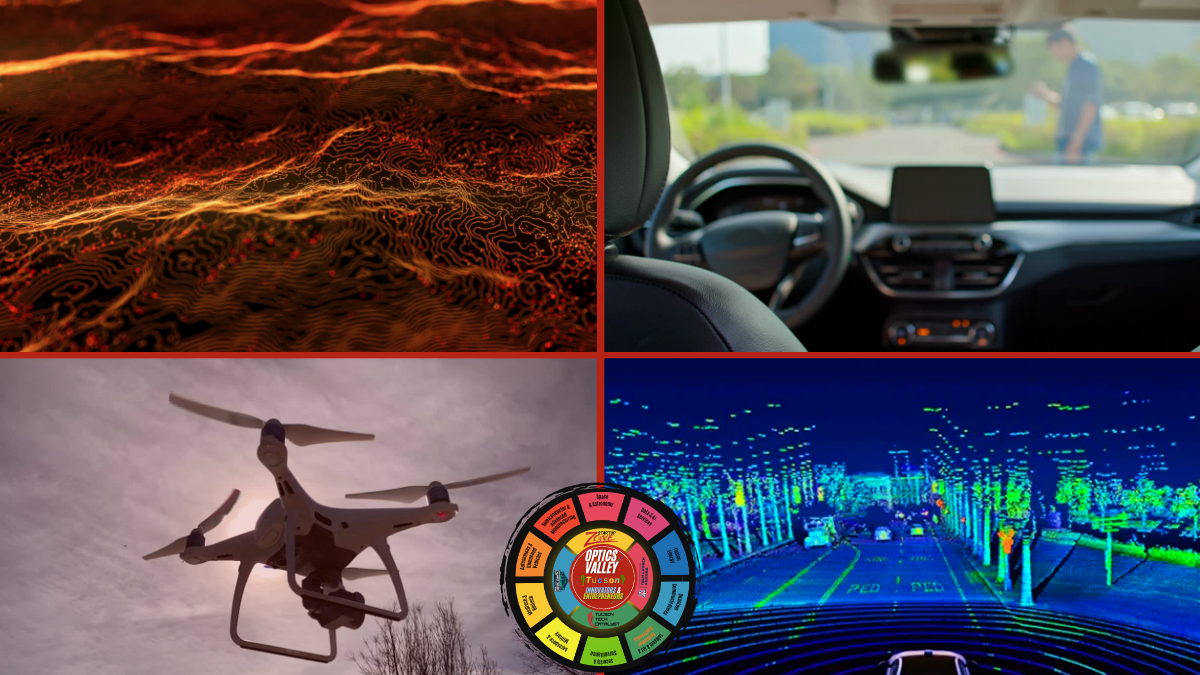
Autonomous Vehicles and Robots
Self-driving cars and robots use LiDAR to “see” the world in 3D. LiDAR helps detect:
- Other vehicles
- Pedestrians and cyclists
- Road edges and lane markings
- Obstacles, curbs, and barriers
Research at the University of Arizona’s CAT Vehicle program, for example, utilizes LiDAR data to recognize and track vehicles, estimating their speeds to enhance the safety of autonomous driving.
Mapping and Surveying
Airborne LiDAR is a game-changer for mapping terrain and cities. It’s used to create:
- Digital Elevation Models (DEMs)
- Floodplain and watershed maps
- Urban planning and infrastructure models
Companies specializing in LiDAR mapping deliver products such as classified point clouds, terrain models, and contour maps for engineering and environmental projects.
Construction, Mining, and Industry
LiDAR is used to:
- Measure stockpiles and mine volumes
- Verify construction as-built conditions
- Create digital twins of factory floors and industrial plants
In Arizona, firms utilize LiDAR scanning to create detailed 3D models of buildings, tunnels, mines, and even ships and aircraft for engineering and safety purposes.
Environment and Climate
LiDAR supports:
- Forest biomass estimates
- Coastal erosion studies
- River and canyon mapping
- Methane and gas leak detection in energy infrastructure
Why LiDAR Matters for Optics Valley (Tucson, AZ)
LiDAR is not just a cool technology. It connects directly to Tucson’s identity as Optics Valley, a globally recognized cluster in optics, photonics, and astronomy centered around the University of Arizona. Here’s why it’s such a strategic fit.
LiDAR Is Photonics at Its Core
LiDAR depends on:
- High-quality lasers
- Precision optical components
- Sensitive detectors
- Rugged optical packaging and alignment
These are precisely the strengths that Tucson and Arizona have built for decades, through assets like:
- Wyant College of Optical Sciences at UArizona
- A deep base of optics manufacturers, coating shops, metrology labs, and laser design teams
LiDAR sits right at the intersection of this expertise.
Defense, Space, and Aerospace Need LiDAR-Class Sensing
Southern Arizona is home to major defense and aerospace players that rely on advanced sensing:
- Long-range detection
- Targeting and tracking
- Mapping and surveillance
- Space-based sensing, including LiDAR data analysis contracts
As the Department of War and space agencies adopt more autonomous systems and advanced sensing platforms, regions that understand both lasers and systems integration have a strong advantage. That describes Tucson.
Perfect Testbed: Desert, Mountains, and Clear Skies
Tucson’s geography and climate are ideal for LiDAR testing:
- Clear skies for much of the year
- Open desert and rugged terrain
- Mix of urban, suburban, and rural environments
Autonomous vehicles, drones, and defense systems need reliable outdoor testing. Tucson can host year-round experiments that other regions struggle to support.
Deep-Dive: LiDAR and LiDAR-Enabling Companies in Arizona
Arizona doesn’t just consume LiDAR sensors. It builds the lasers, optics, and systems that make LiDAR possible and turns LiDAR data into real-world solutions. Here’s a snapshot of the ecosystem.
Laser and Photonics Manufacturers Serving LiDAR
These companies don’t always sell “LiDAR boxes,” but they supply the lasers and optical engines that LiDAR systems need:
- AdValue Photonics (Tucson) – Manufactures innovative fiber lasers and amplifiers for markets including materials processing, scientific research, LiDAR, and medical applications. Their proprietary fiber-laser technology focuses on high performance and cost-effectiveness, making them a natural supplier for LiDAR source technology.
- NP Photonics (Tucson) – Builds specialty fiber lasers and amplifiers used in coherent communications and LiDAR applications. Their products emphasize low noise and high stability traits that are critical for advanced LiDAR and sensing systems.
- Leonardo (Tucson laser solutions unit) – Operates a laser-solutions business in Tucson, highlighted during Arizona Photonics Days, focusing on high-end laser technologies with clear relevance for defense, aerospace, and advanced sensing.
- Edmund Optics (Tucson facility) – Runs an assembly and advanced design facility in Tucson, increasing domestic capabilities in precision optics and assemblies. These kinds of facilities are essential for building LiDAR optical sub-systems at scale.
Together, these firms provide the building blocks for LiDAR engines: fiber lasers, amplifiers, precision optics, and optomechanical assemblies.
Imaging and Sensor Specialists
Some companies focus directly on the imaging and sensor side:
- The Sensor Group (Optics Valley member) Designs and manufactures imaging devices and systems, including custom focal-plane integrated circuits and camera assemblies. Its directory tags explicitly include LiDAR, LiDAR IC, and ASIC, showing its role in providing specialized detectors and electronics for LiDAR and other demanding sensing applications.
These organizations help turn raw laser light into usable, high-fidelity signals for perception systems.
LiDAR Mapping, Scanning, and Digital Twin Services
Arizona also has companies that operate LiDAR systems in the field and turn raw point clouds into actionable models:
- Darling Geomatics (Arizona) – Branded as “Arizona LiDAR trailblazers,” they’ve spent two decades using state-of-the-art 3D laser scanning. Their work includes tripod, mobile, and aerial LiDAR for as-built verification, as well as digital twins of buildings, ships, aircraft, underground mines, tunnels, and more.
- Volare LiDAR (VL) – Provides data processing for georeferenced LiDAR products such as classified point clouds, digital terrain and elevation models, contour maps, and orthomosaics. Their applications include power-line corridors, railways, pipelines, mining, floodplain mapping, and urban surveying.
These service providers demonstrate how LiDAR delivers real value, enabling engineers, utilities, and governments to make informed decisions.
Research Labs and Talent Pipelines
Tucson’s strength in LiDAR is reinforced by its research ecosystem:
- The Advanced Lidar and Display Lab at the University of Arizona’s Wyant College of Optical Sciences focuses directly on advanced LiDAR and related display technologies.
- The CAT Vehicle program and broader UArizona autonomous-systems research use LiDAR for real-time vehicle detection, tracking, and safety algorithms.
- Optics Valley itself, a committee of the Arizona Technology Council, serves as a hub for optics and photonics businesses, offering a searchable Resource Directory where companies can tag themselves with LiDAR-related capabilities and connect with partners and customers.
This combination of research, industry, and networking is exactly what you need for a growing cluster.
The Big Picture
LiDAR is more than a sensor on a self-driving car. It’s a platform technology:
- Built from lasers, optics, detectors, and precision engineering
- Used in autonomy, mapping, construction, mining, environment, and defense
- Powered by complex software, AI, and data processing
For Tucson/Optics Valley, LiDAR sits at the heart of what the region already does best: turning light into useful technology.